Wood County, Ohio Zoning Maps and Regulations show how land is divided and used across the county, including residential, commercial, industrial, and agricultural areas. While most zoning is managed at the township level, the County Planning Commission oversees overall land-use planning, subdivisions, and development in unincorporated areas. These maps and rules help property owners and developers follow proper guidelines, support orderly growth, and protect community character.
What Is Zoning and Why It Matters
Zoning divides land into districts like residential, commercial, or industrial and sets rules for how each area can be used. It matters because it organizes growth, protects property values, prevents land-use conflicts, and keeps communities safe and well-planned.
The Main Goals of Zoning Include:
- Organized Growth: Ensure development happens in a planned and orderly way.
- Protect Property Values: Prevent incompatible uses that could lower surrounding property values.
- Public Safety: Separate uses that could be hazardous or disruptive.
- Community Character: Maintain the look, feel, and purpose of neighborhoods.
- Efficient Services: Help local governments plan roads, utilities, and public services effectively.
How Zoning Affects Property Owners
Zoning directly impacts what property owners can do with their land. It determines the types of buildings allowed, how land can be used, and any restrictions on size, height, or placement of structures. Compliance with zoning ensures legal use of property, while violations can lead to fines or required changes. Proper zoning also helps protect property values and neighbourhood character, giving owners confidence that surrounding land uses won’t conflict with their plans.
- Residential Zoning: Limits homes to single-family or multi-family use, controlling density.
- Commercial Zoning: Allows stores, offices, and restaurants but restricts industrial operations.
- Industrial Zoning: Permits factories and warehouses but separates them from homes.
- Agricultural Zoning: Protects farmland and limits non-farming development.
- Mixed-Use Zoning: Combines residential and commercial uses in planned areas.
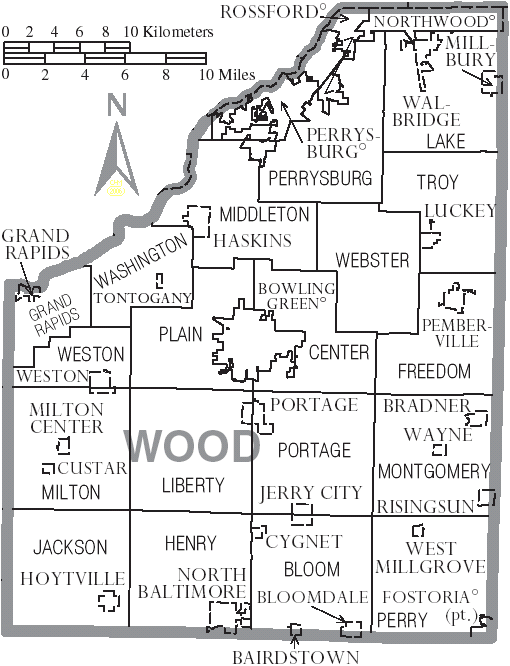
Wood County Zoning Map Overview
Wood County, Ohio, uses zoning maps to show how land is divided into districts like residential, commercial, industrial, and agricultural. Most zoning is managed by townships, while the County Planning Commission oversees development in unincorporated areas. These maps help property owners, developers, and officials understand allowed land uses, maintain community character, and plan for growth. Zoning maps are available online through the Wood County GIS portal for easy access and reference.
Visit the GIS Portal: Go to the Wood County GIS website: wcohgis.woodcountyohio.gov.
Open the Zoning Map: Look for the zoning layers or “Aggregate Township Zones” option.
Search Property: Enter the property address or parcel number to locate your area.
View Zoning Info: Click on the parcel to see zoning classification and any restrictions.
Download/Print: Most maps can be downloaded as PDFs or printed for reference.
Reading Zoning Map Codes and Colours in Wood County, Ohio
Wood County zoning maps use colours and codes to show land-use types:
- Residential (R): Light yellow single-family or multi-family homes.
- Commercial (C): Red retail stores, offices, and restaurants.
- Industrial (I): Gray or purple factories, warehouses, and manufacturing.
- Agricultural (A): Green farmland and rural uses.
- Mixed-Use (MU): Orange areas allowing both residential and commercial activities.
Types of Zoning Districts in Wood County, Ohio
Wood County uses several zoning districts to guide land use and development:
- Residential (R): Light yellow for single-family and multi-family homes; controls density and lot size.
- Commercial (C): Red for retail stores, offices, restaurants, and service businesses.
- Industrial (I): Gray or purple for factories, warehouses, and manufacturing operations.
- Agricultural (A): Green preserves farmland and limits non-farming development.
- Mixed-Use (MU): Orange allows both residential and commercial uses in planned areas.
- Public / Special Purpose (SP): Blue or similar includes schools, parks, government buildings, and utilities.
Zoning Regulations and Permits
Zoning regulations in Wood County set rules for how land can be used, what types of structures are allowed, and where they can be built. Property owners must comply with these rules to ensure legal development. Common requirements include building setbacks, lot size, height limits, and land-use restrictions.
To build, expand, or change the use of a property, a zoning permit is often required from the township or county Planning Commission. Permits ensure the project meets zoning standards, protects neighboring properties, and maintains the community’s character. Failing to get a permit can lead to fines, stop-work orders, or required modifications.
How to Apply for a Zoning Change or Variance
If a property owner wants to use land in a way not allowed by current zoning, they can request a zoning change (rezoning) or a variance (exception). The steps usually include:
- Contact the Township or County Planning Office: Discuss your request and get the required forms.
- Submit an Application: Provide property details, proposed use, and any supporting documents.
- Public Notice: Some requests require notifying neighbors or posting a public notice.
- Planning Commission Review: The commission evaluates the request for compliance with zoning rules and community plans.
- Board or County Approval: A township zoning board or county authority makes the final decision.
Approval may include conditions to ensure the change fits the area and protects neighbouring properties.
Conclusion
Zoning in Wood County, Ohio, guides land use, protects property values, and ensures orderly development. Understanding maps, codes, and permits helps property owners follow rules and maintain community safety and character.
FAQs
Q1: What is zoning?
A: Zoning divides land into districts (residential, commercial, industrial, agricultural) and sets rules for how each area can be used.
Q2: How do I find the zoning for my property in Wood County?
A: Use the Wood County GIS portal or contact your township or the County Planning Commission.
Q3: Do I need a permit to build on my property?
A: Yes, most construction, expansions, or land-use changes require a zoning permit from the township or county.
Q4: What is a zoning variance?
A: A variance is an exception to zoning rules, granted if strict compliance causes hardship or is impractical.
Q5: How can I request a zoning change?
A: Submit an application to your township or the County Planning Commission. It may involve public notice and review by the zoning board.
Q6: Why do zoning maps use colors and codes?
A: Colors and codes quickly show land-use types and allowed uses, making maps easier to read and understand.